There is no doubt that drones are becoming an integral part of both our daily lives and those of many different companies. One important related technology that is constantly being developed and used to help open up new potential for businesses and projects is LiDAR. This innovative technology is a game changer in its market already and when coupled with the drone technology, various new applications are emerging out of it. Let us first understand what LiDAR technology is.
What is LiDAR?
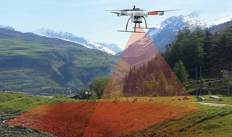
A laser is essentially used by LiDAR, which stands for light detection and ranging, to collect data and aerial imaging data about surfaces. The LiDAR scans a target from a distance using light pulses. The purpose of the powerful lasers is to blast the target with pinpoint accuracy from a distance. Following that, information will be gathered by measuring the pulses that are returned from the subject. The entire procedure is comparable to how sonar uses soundwaves to travel. The lasers that the LiDAR technology uses are of two types:
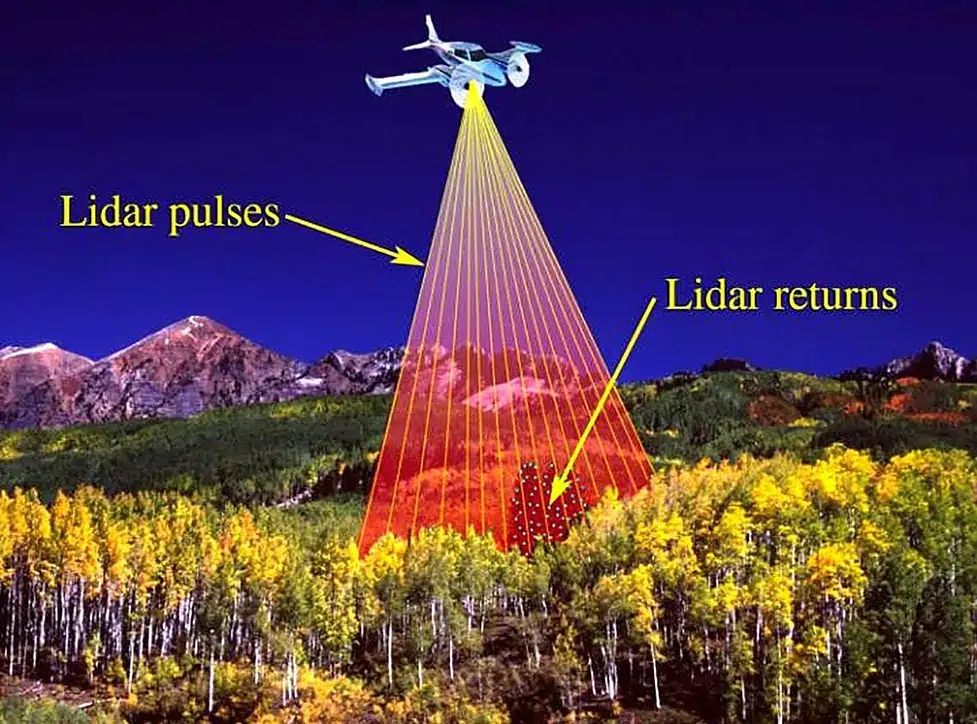
- The “Pulse” is the laser that is emitted from the device and strikes the target.
- The “Return” is the laser that bounces back from the target and is received by the device.
The time taken by the laser to strike and bounce back to the device is used to calculate the depth of the object from the device and also the magnitude of distances in other axes. To create an understanding of an object in three dimensions, LiDAR sensors measure:
- Time—how long it takes for the pulse to return.
- Intensity—the return strength of the laser pulse.
- Angle of the reflection—the ways the surface being measured change as indicated by the angle of reflection.
Once these data points have been gathered, they are processed by specialist 3D mapping software combined with GPS (Global Positioning System) and INS (Inertial Navigation System) data to produce accurate and comprehensive 3D representations of a specific region or item.
LiDAR enabled drones: Use cases
Previously, the most common way to use LiDAR technology for topography mapping was to use aeroplanes that would measure the long distances. This was certainly an expensive and exhausting effort and could only be used for open spaces that allowed the required space for the planes to fly. The drones have come out as a way better alternative, let us see how.
The cost and size of LiDAR sensors have significantly decreased in recent years due to progress in the field of LiDAR technology, making it easier to mount a LiDAR payload on a drone. Additionally, when LiDAR drones are used more often, the information they can deliver is both far more affordable and precise. With an absolute precision of 4 inches horizontally and 2 inches vertically, a fixed-wing drone equipped with a LiDAR sensor can survey an area of up to four square miles in a single trip. This is some of the highest fidelity data currently achievable by any aerial surveying method.
LiDAR in drones has also found some serious applications in various domains ranging from surveillance of a system to historic archaeological explorations.
Revolutionising archaeology:
LiDAR drones are playing a very critical role in surveying areas that might have a historic significance. As these sites are very less explored and are typically found in tough places like caves or dense forests. They require precision techniques that have minimal error scope and are able to perform a detailed scan.
LiDAR drones serve this purpose very well as they can fly much closer than any planes, can manoeuvre in closed spaces and are precise enough to leave minimal scope of error.
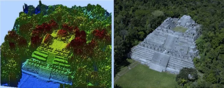
- In 2017, data obtained by LiDAR drone sensors assisted in the identification of a massive road network in the El Mirador river basin, a sizeable area of land buried deep inside Central American rainforests. Without the use of LiDAR drones and the technology’s unique capacity to collect data through dense and vast tree top canopies, these roadways, utilised by the Mayans as early as 600 B.C. could never have been found.
Analysing and blueprinting structures for identifying defects:
Sites that are complex, underground or near water bodies are difficult to map without deploying a workforce. These sites can be government projects like dams or a state’s water system or mining projects. Drones are the best alternative to human intervention in these cases as they eliminate the risks and can reach places that are very tough to inspect.
- Drones can be used to generate historical records for a site as they can be frequently deployed to the site. This helps in determining the changes that the site might undergo in the long run.
- LiDAR drones can speed up the inspection process and reduce downtimes. Getting a detailed 3D rendering of an asset or space can help plan future work and make sure no details are missed.
The Water Department of Lausanne is responsible for administering the city’s complete water cycle, including sewage management, maintenance, purification, and storage of the city’s drinking water. All of the city’s water-related assets must be routinely monitored and maintained by department employees as part of their job duties. These inspections are dangerous for the following reasons:
- Inspectors who enter these vaults for inspection run the risk of being exposed to gases, biohazards (such as human waste), and restricted space exposure.
- Inspectors are put in greater risk since inspecting the tank’s slabs necessitates working at a height on scaffolding.
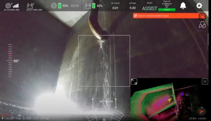
The use of drones by the department has benefitted them as the LiDAR drones can create thorough 3D models of interior areas in assets. These models may be used to track changes over time and rebuild the building as it was when it was first created. The LiDAR drones also pinpointed each defect observed in inspection data using the 3D model. This also increased the safety and decreased the manual labour as inspectors could go back to the precise spot where a flaw was first discovered.
Nature conservation:
- Forest conservation: Mapping forests to conserve and protect them.
- Water conservation: LiDAR drones can map out everything from flood plains to water basins, and with accurate, high fidelity maps of these areas, state and local governments can both prepare for natural disasters and more accurately predict their yearly resource use.
- Sand dune conservation: Mapping sand dunes to track their spread and incursion on bordering ecosystems, and to protect them.
The Routescene UAV LiDAR System RS4 was used to scan a wooded area (10.9 acres/4.4 hectares) close to Barnsley in Yorkshire, United Kingdom. It has a large field of vision, 32 distinct lasers, and a scan rate of up to 1.4 million points per second in dual return mode. In order to map the ground and individual trees to a high degree of detail, the system must be able to penetrate thick foliage. The drone was flown at an average height of 45m and a velocity of 5m/s. This enabled the UAV LiDAR System to collect a total of 8,912,679 points, used to create an incredibly dense 3D georeferenced point cloud. Using these data points the average height of the trees in the forest was calculated which then gave insights on how old the forest is and how frequently has it been cut down. The percentage of LiDAR returns recorded at different tree height percentiles have been used alongside canopy cover and canopy density metrics to detect canopy defoliation associated with disease.
The LiDAR system is one of the very powerful tools that when integrated with drone technology, provides astonishing results in terms of various insights and findings. The future of these LiDAR drones points towards drones that self detect and self repair the smaller defects that they find, or the currently in progress drones that can sow the seeds in the required area during a survey. More research needs to be done in this field as it can assist in tasks that are tiring for manual labor and is exponentially more effective in tackling various scenarios.