Drones have been trending ever since people have found the various applications of them in their lives, be it a movie shoot, an adventure sport like base jumping, or more essential things like package delivery or say monitoring and analytics. Drones have become a perfect example of how innovation can evolve with time and find its use in various aspects of your daily life. Some of the most common yet critical applications of drones have been shown below. Although the ones mentioned here are just a handful from the hundreds of applications that we see today. Diving a little deeper into how they are being used and their benefit over traditional methods will surely make one think over it again and again.
Drones in precision agriculture
The modern farming business has reached a crucial turning point as a result of the growth of food production and consumption needs, with the world’s food supply diminishing more quickly than ever before and commodity prices surging like never before. Climate change is also making it more difficult for the agriculture sector to maintain the security of the supply chain. As part of a comprehensive sustainable farming strategy, drones are growing in popularity in agriculture. They enable agronomists and farmers to streamline procedures while acquiring crucial information about their crops through in-depth data and topographical analyses. The technology may be especially helpful in aiding farmers to evaluate damage over land terrains that may be unreachable if you’re on foot after natural catastrophes, like flooding. Some of the uses for drones in precision agriculture include the following:
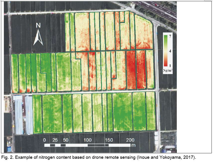
- Crop surveying and mapping: Time-lapse drone photography, for example, can be used to precisely monitor yield growth and development over several days or weeks, and drone-driven NDVI mapping, which employs specialised sensors, is extremely useful for analysing chlorophyll levels, detecting insects, pests, and disease, identifying weeds and measuring plant stress levels.
- Pest control and weed management: Large areas may be accurately tracked in a matter of seconds with the help of drones equipped with sophisticated cameras and sensors that can identify specific weeds and pests as well as GPS technology that can provide position information for field mapping. Drones provide for more accurate weed strategy planning, boosting the effectiveness of mechanical techniques and reducing herbicide growth, which lowers costs, delays the development of weed resistance, and boosts biodiversity.
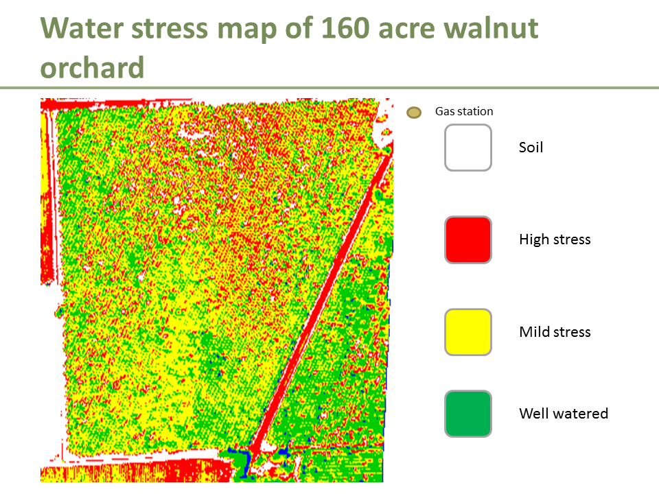
- Soil-water inspection: The data from aerial mapping may be utilised to further assess the soil’s condition and calculate the crop yield, which shows how closely mapping and soil analysis are connected. A quadcopter-style drone, a vector network analyzer (Planar R60), an antenna, GPS, and a ground-penetrating radar (GDR) device for the mapping and monitoring of soil moisture. By using full-wave inverse modelling on the radar data, the soil moisture is determined.
- Field spray management: The precise location of extra nutrient needs may be determined by UAVs using cutting-edge sensor technology, allowing nutrients to be given only where they are most required. In addition to being excellent sprayers, drones may successfully reduce the quantity of fertiliser released by up to 20% by providing the exact right amount of plant food at the exact right moment.
Crowd control/management using drones
The monitoring of crowds using a UAV (Unmanned Aerial Vehicle) is a real-time application of drones that is used for crowd control; this technique is gaining popularity with the goal of saving human lives, preserving the environment, protecting property, keeping the peace, and upholding governmental authority. In this study, a pedestrian crowd monitoring system has been suggested and put to the test. Using real-time photos captured by UAVs, the system has implemented a crowd monitoring approach. The acquired data has been examined, and crowd density has been calculated using image segmentation techniques. Under various camera placements and orientations, a colour-based segmentation algorithm has been used to detect, identify, and map crowd density.
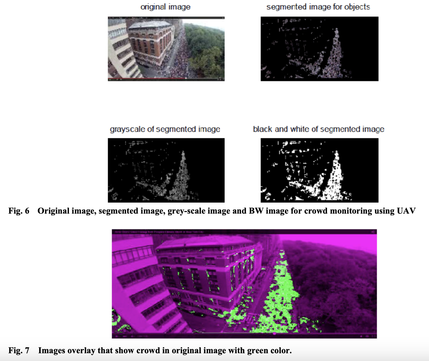
The findings indicate that the employed picture segmentation approach can map the crowd densities with an acceptable accuracy as high as 80%. It is crucial to consider crowd safety and risk analysis when dealing with crowd dynamics in large-scale gatherings of people for sporting, religious, and cultural events. Stampedes in large gatherings are common, according to historical patterns from the Kingdom of Saudi Arabia, which hosts thousands of pilgrims every year during the Hajj and Umrah seasons. These patterns emphasise the significance of understanding and managing crowd dynamics more thoroughly. In this sense, the hazards connected with such a large gathering have been reduced by effective monitoring as well as other safe crowd control approaches.
To ensure everyone’s safety and effectively coordinate drone interventions, it is essential to be able to survey the whole scene, focus on questionable circumstances, and stay in constant visual communication with the team on the ground.
Drones in border patrol and surveillance
Drones in border patrol have been in use since World war 2. Drones can be quickly deployed into locations where sending a human would be challenging and time-consuming. Drones can instantly reach any location and remove blind spots. If a thermal camera is present, nighttime surveillance is also an option. Periodic patrolling may be automated using a drone fleet. A drone can follow and monitor an intruder, giving reaction teams real-time situational knowledge. Even patrol guard cooperation may be checked using drones.

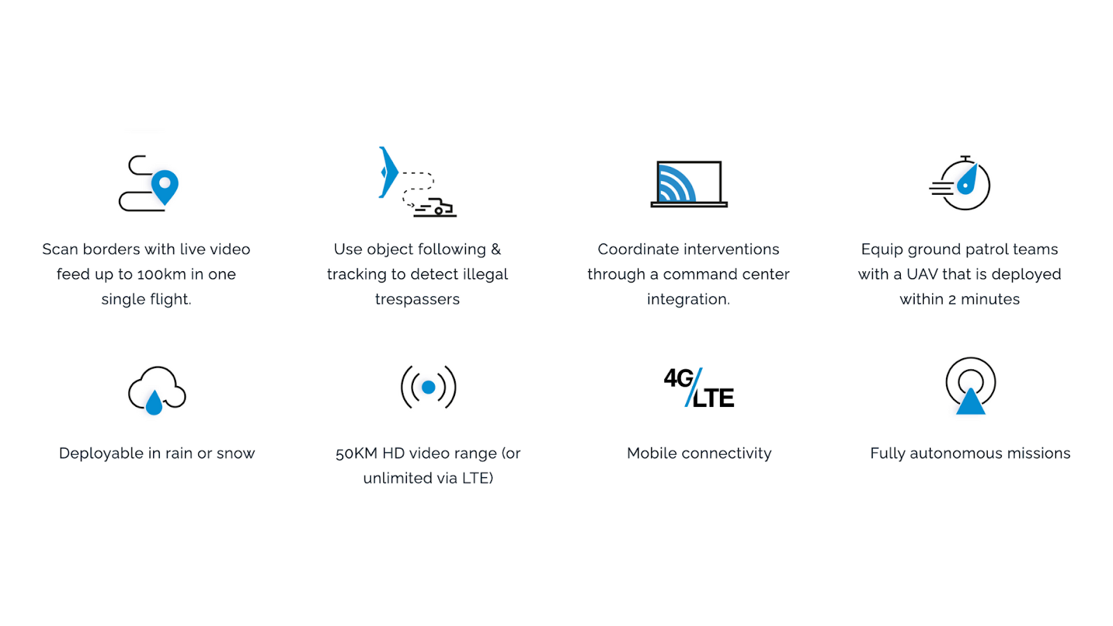
Similarly a number of applications have been seen during COVID-19 lockdown in India, where drones have been essential in public place surveillance. Live video streaming: A drone linked to the live streaming system is able to transmit a high-definition, live video feed straight to the operator’s cloud dashboard, where they may choose to share the broadcast with several distant stakeholders.
This function was essential during the COVID-19 shutdown in India in 2020. Drones were flown all around Ahmedabad, an Indian city in the state of Gujarat, by a startup company named Dronelab with the assistance of volunteers and the police. The video feed from the drones was fed straight into the software dashboard at the main control centre. This made it possible for the police to keep a close look out for anyone disobeying the government-imposed lockdown or breaking societal conventions of distance.